FordPass Performance App for Bronco: Part 2

Bronco
Mar 06, 2021
4

UPDATE: The new Bronco Trail App is ready for use! Check it out

Keep reading to learn the backstory of the app from early in 6 Gen history.

Part 2: A Map to the Wild

In Part 1 of this series, we introduced you to the FordPass Performance App and to Shane Coloney, Ford’s Senior Product Manager for Navigation. Today, we’re showing you what the planning and in-Bronco experience will be for FordPass Performance.

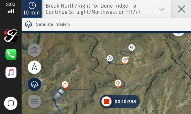
We think the FordPass Performance App is one of the most fascinating features of the 2021 Ford Bronco. Earlier this week, we introduced you to Shane Coloney, the leader of the team that is putting together this groundbreaking experience that will give some key tools to help you plan adventures. Today, we’re going to talk about that planning experience and how the FordPass Performance App can serve as your map to the wild.

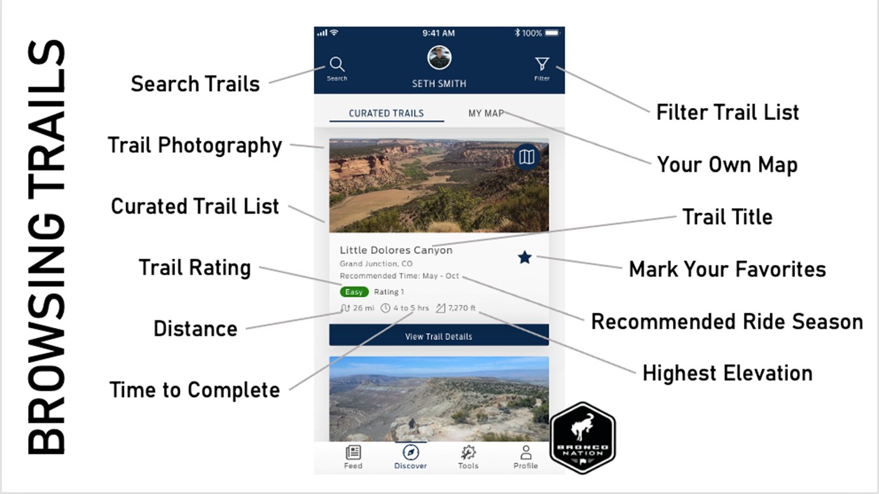
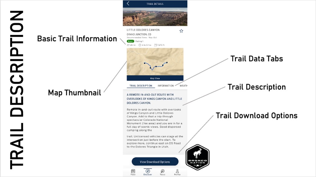
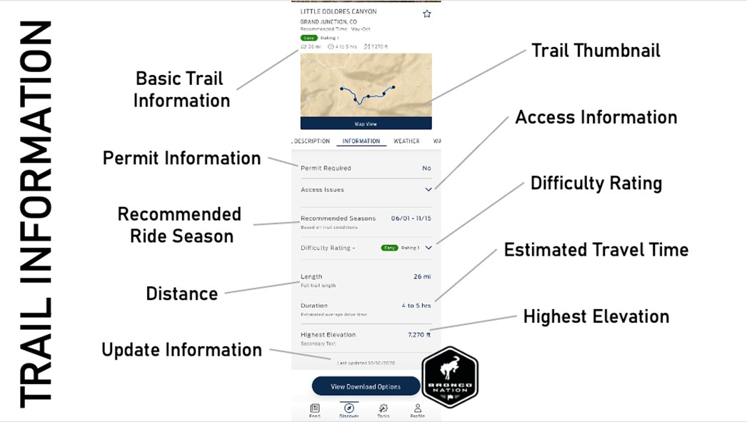
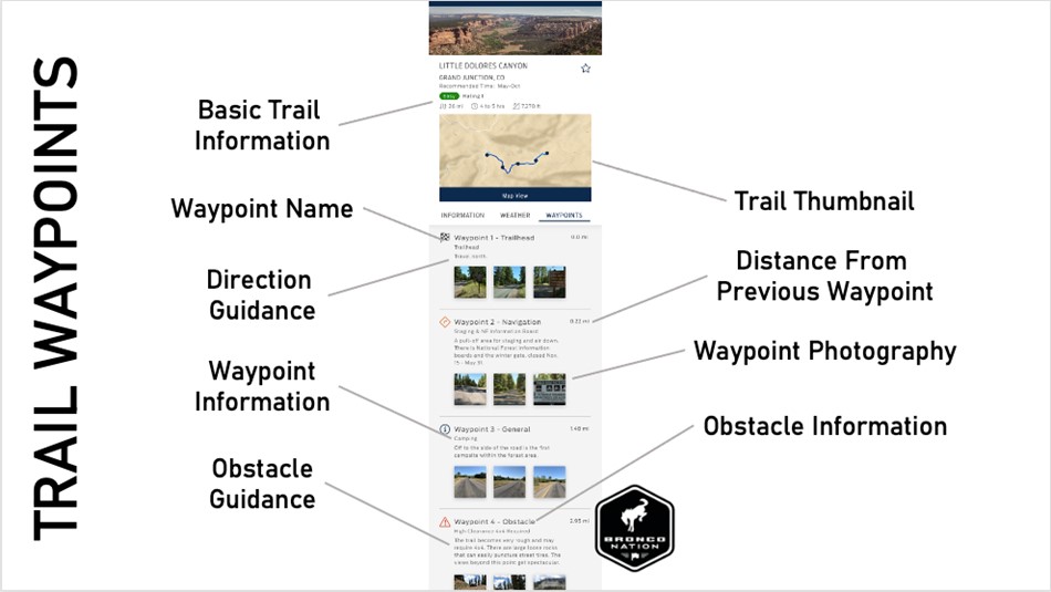
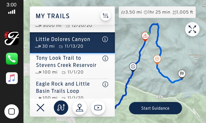
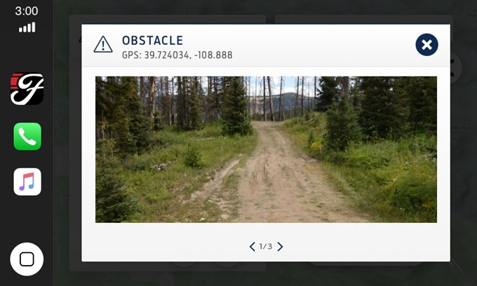
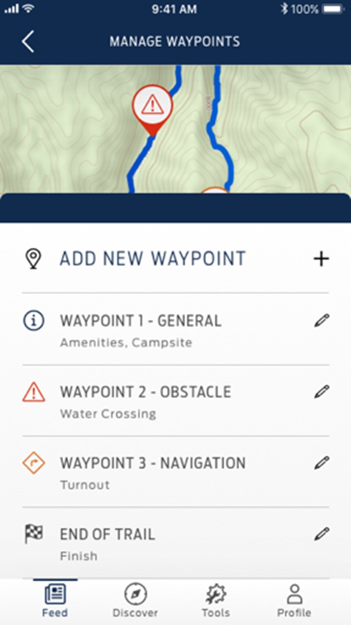
Getting to the wild starts with knowing where to go. The FordPass Performance App has over 2,000 curated trails that you can explore. Each trail has been mapped out by a survey team that actually traveled the route, noted obstacles, and set waypoints. As you scroll through the trail list, you’ll quickly see basic information for each trail, like its difficulty rating, estimated time to complete, distance, and highest elevation. In screenshots provided to Bronco Nation, it appears that users can select “favorite” trails from the list, which will then show up in your personal curated list on your vehicle screen.

Browsing Trails guide

When you select a trail for viewing, you’ll have a number of tabs available that give you important information for planning your trip. Regardless of which trail information tab you’re viewing, you’ll see a persistent thumbnail of the trail on a map, along with that basic information regarding distance, travel time and max elevation. You can “favorite” the trail and add it to your curated list while in any tab.

The first tab is the “Trail Description” tab, which gives you a rundown of what the trail is like. The “Trail Information” tab lays out the nitty-gritty details of the trail. Thankfully, for folks like me that aren’t familiar with the rules and customs of traveling in public lands out west, there’s permit and access information included. This tab also lists key info like distance and elevation, plus “recommended ride season,” which helps you plan what trails to ride when. It’s also very important to note the last updated timestamp, as it lets you know how long it’s been since the trail information has been at by the survey team.

Further aiding your planning, a “Trail Weather” tab gives you not only the current weather in the vicinity of the trail, but also an hourly forecast through the next few hours. This should be especially helpful in places that have highly variable weather conditions, like many mountain regions. If you’re planning your adventure further out, a ten-day forecast is also available.

In the final tab, "Trail Waypoints", the information really gets granular. Each trail has a set of waypoints that will help guide you through your ride. Since trail navigation can’t rely on things like crossroads, you need clear landmarks to know if you’re on the right track. So instead of the turn-by-turn navigation that you would have while driving on-road, you’ll have waypoint-by-waypoint navigation off-road. Photographs are included to give you a better sense of what you’re looking for, and distance between waypoints is given so you can know if you went too far and missed one. Obstacles are also noted, and guidance on how to tackle each seems to be included, as well. In addition, advice like, “High Clearance 4x4 Recommended” is also noted… good thing you’re in a Bronco.

Shane Coloney — Ford’s Senior Product Manager for Navigation — also mentioned that waypoints can be dropped by the user. If you decide to venture down a branch of a trail that hasn’t been surveyed yet, you can drop your own breadcrumbs, so that you don’t get lost while you’re exploring. This is accomplished from the in-vehicle screen and can be saved and shared later.

In our briefing with Ford, Shane discussed the high fidelity of the mapping that Ford is using to build this app. A highly detailed topographic base map, provided by AccuTerra, covers all of North America. There’s also satellite imagery available. This map information can be downloaded, which ensures it will be available/accessible — even when you’re riding in a spot with no cell coverage. The robust GPS system that is included in Mid-package Broncos provides your real time position on that map.

Now that you’ve planned out your trail ride, what’s it like to use the app as you go down the trail? The app is available in Apple Carplay and AndroidAuto, so you don’t have to leave those environments if you don’t want to. This amazing experience happens entirely on the 8” or 12” display in your Bronco. Also, according to Shane, Ford’s Sync 4 system allows for easy switching between the CarPlay or AndroidAuto environment and the native Sync 4 environment. So if your Bronco is properly equipped, you can switch over to the Trail Cam for the technical portions of trails and then quickly get back to FordPass Performance.

One final thing to note, is that much of this experience seems to center around slower and more deliberate off-road travel. There’s a lot of information available, and using it to the fullest seems to call for reviewing the information thoroughly both ahead of time and en route. Processing and using the information is probably best done at a stop on the trail. You can read the trail description beforehand, and look at the information in the “Trail Waypoints” tab before heading down the trail. Once you’ve chosen the trail you want to ride, add it to your favorites…and you’re ready to go. Then jump in your Bronco, proceed to the trail head and hit the “Start Guidance” button.

Following the guidance from the start, you’ll know that you’ve reached the next waypoint by comparing what you see around you to the photos included in the waypoint description. If you’re ever unsure if you’re in the right place, waypoints are marked with their precise GPS coordinates, so you can tell if you’re close.

Now, from what we’ve seen, Ford seems to be using the term “obstacle” quite broadly, for a range of challenges on the trail. Everything from muddy, rutted areas to water crossings might be marked as an obstacle. The example provided in this photo doesn’t seem like much of an obstacle for a 2021 Bronco, but we aren’t the folks who saw it on the ground and we all know looks can certainly be deceiving in the wild. Other examples seemed like more significant (AKA fun) challenges to us.

All of this comes in an app that is free to use on any Bronco that has the Mid package. There’s no subscription. According to Shane, the app only confirms there’s a FordPass account and that the Bronco has the Mid-package hardware to ensure that it can operate as advertised. Ford seems to have shot for the broadest user base possible. Owners of a Base Bronco won’t have access and that’s a bummer. Those folks can obviously use other navigation apps, but they will miss the deep integration with the vehicle that comes with FordPass Performance.

That being said, if you have a Big Bend with Mid package or above, how can you share your FordPass Performance experience with others? Well, that’s coming in Part 3. We’ll see you there.

In the meantime, how does the FordPass Performance App sound so far? Join the discussion with other Bronco Nation members over in the forum now.

Comments

You must log in or register to post here.