Bronco Nation Trail Briefs | Northern Arizona

May 25, 2022
2

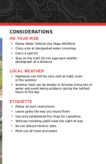
Here at Bronco Nation, we get excited about Broncos, and we get excited about the special, out-of-the-way places that Broncos can take us. In this series, we’re going to cross the country, highlighting a few of the best trails in each region. Before you go off-road, you want to know what type of terrain you can expect and what equipment you should pack, so you can have the best trail ride ever.

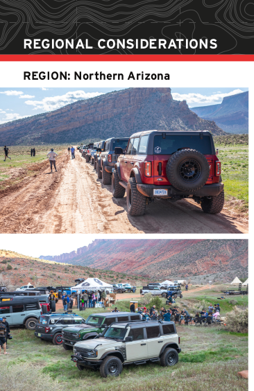
We recently traveled to Flagstaff, Arizona for Overland Expo West, and Bronco Nation's David and Bronco historian (and AZ local) Todd Zuercher put together a list of trails for owners to try out. If you weren't able to join us on the trip and grab one of these booklets, here's what you missed. While we do our best to rate trails appropriately, skill level, seasonality, and weather contribute to difficulty and length of time. We recommend doing your own research before you go, and always proceed with caution.

Schnebly Hill Road

Location: N34 52.962 W111 44.919

Distance: 11 miles, 1-1.5 hours

Description: Schnebly Hill Road is an easy trail that leads to some beautiful views above the town of Sedona. Originally a wagon trail, the road is named for Carl Schnebly, a local entrepreneur that was responsible for naming the town after his wife, Sedona.

The trail is appropriate for any high-clearance 4x4. Leave some time on your run to enjoy the incredible views at Vista Point, about 5.4 miles past the trailhead.

Grandview Lookout and Rim Trail Road

Location: N35 58.127 W112 07.687

Distance: 17 miles, 2-3 hours

Description: Located near Grand Canyon National Park, the Rim Trail Road is an easy excursion for any trim of Bronco. Start at N35 58.127 W112 07.687 and proceed into Kaibab National Forest on FS 302. Turning right at N35 56.294 W111 56.303 will put you on the Rim Trail Road. Turning left will take you to Grandview Fire Lookout. Continuing past the lookout will take you into Grand Canyon National Park.

There’s plenty of free dispersed camping in Kaibab National Forest, just make sure to leave your campsite better than you found it!

Cinder Hills OHV Area

Location: N35 19.708 W111 31.600

Distance: 15.2 miles, 2 hours

Description: Cinder Hills OHV Area isn’t your typical free-ride area. The name is taken from the predominance of volcanic ash in vicinity. The ash can be loose and gravelly, so be ready to air down and bring a set of recovery boards.

Portions of the Cinder Hills OHV Area climb to as high as 7,989 feet, so it can be a great escape from the summer heat. Also, there’s plenty of camping in the area, so you can take more than a day to explore.

FS 776 and FS 777 do not allow non-street legal vehicles, but everywhere else in the area does.

Broken Arrow

Location: N34 50.727 W111 45.440

Distance: 3.8 miles, 1-3 hours

Description: One of Arizona’s most iconic trails, Broken Arrow will put your well-spec’d Bronco through its paces. Make sure that you’re familiar with when to engage your lockers and how to put your Bronco into 4L. Sasquatch Broncos shouldn’t have any issues but paying attention to your line and keeping a spotter handy is still advised.

The trail is popular with mountain bikers, hikers, and tour companies, so there may be some traffic that requires reversing in some of the narrow sections.

Smiley Rock

Location: N34 45.118 W112 07.060

Distance: 23 miles, 4 hours

Description: Smiley Rock trail is named for a rock that looks like it’s smiling. You can spot it at about 5.5 miles into your ride. However, given that you’ll need to pay close attention to your line through treacherous Martin Canyon, you might miss it.

Smiley Rock takes you by mining ruins, a ghost town, and the aforementioned Martin Canyon. Look out for challenging rock gardens in the canyon and enjoy the scenic shelf roads running along the Woodchute Wilderness.

Additional Resources
For additional information on these trails and off-roading in Arizona, check out the resources below.

FunTreks Guides
FunTreks guides are some of the best around, they’re updated regularly and are extremely thorough.
Arizona Backroads & 4-Wheel-Drive Roads
Charles A. Wells & Matt Peterson

onX Offroad
A powerful route planning and navigation tool, onX Offroad has been indispensable for our trail planning.

Which trails in this region do you enjoy? Tell us in the forums!

Comments

You must log in or register to post here.