Bronco Nation Trail Briefs | Best of the Southeast

Aug 03, 2021
1

Here at Bronco Nation, we get excited about Broncos, and we get excited about the special, out-of-the-way places that Broncos can take us. In this series, we’re going to cross the country, highlighting a few of the best trails in each region. Before you go off-road, you want to know what type of terrain you can expect and what equipment you should pack, so you can have the best trail ride ever.

THE SOUTHEAST

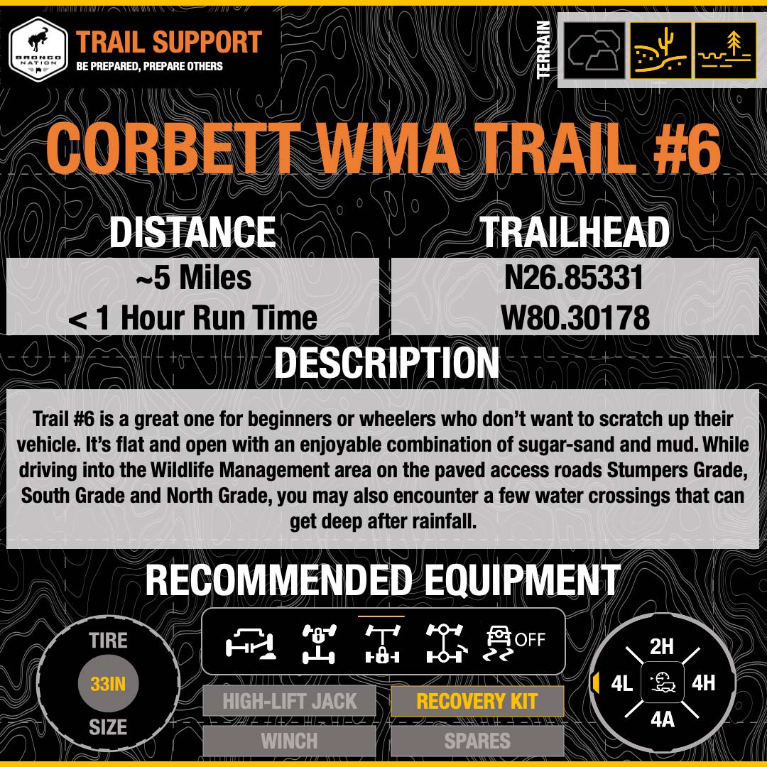
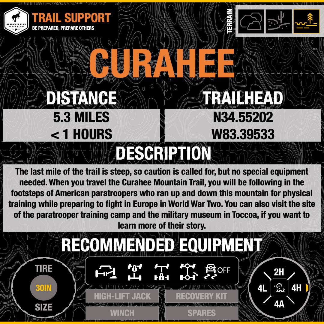
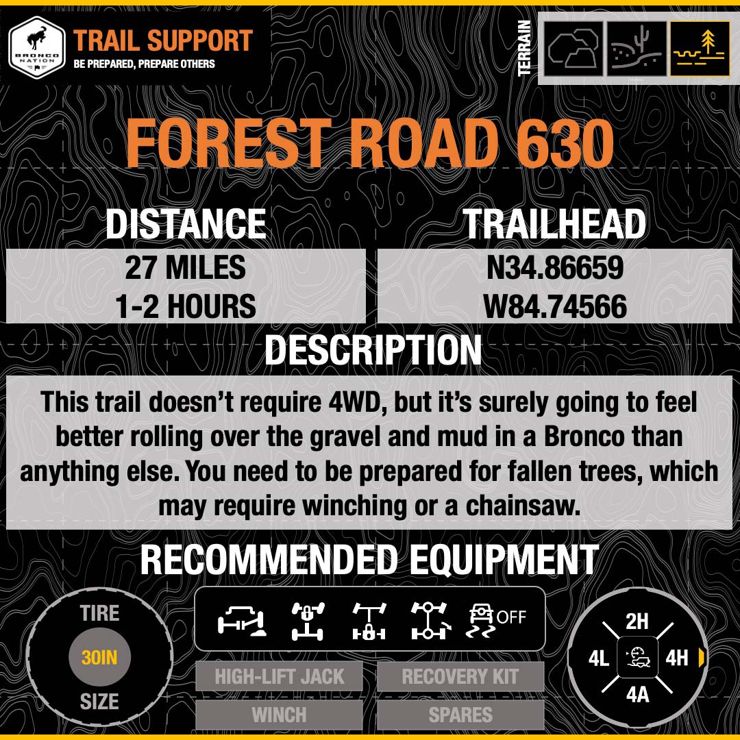
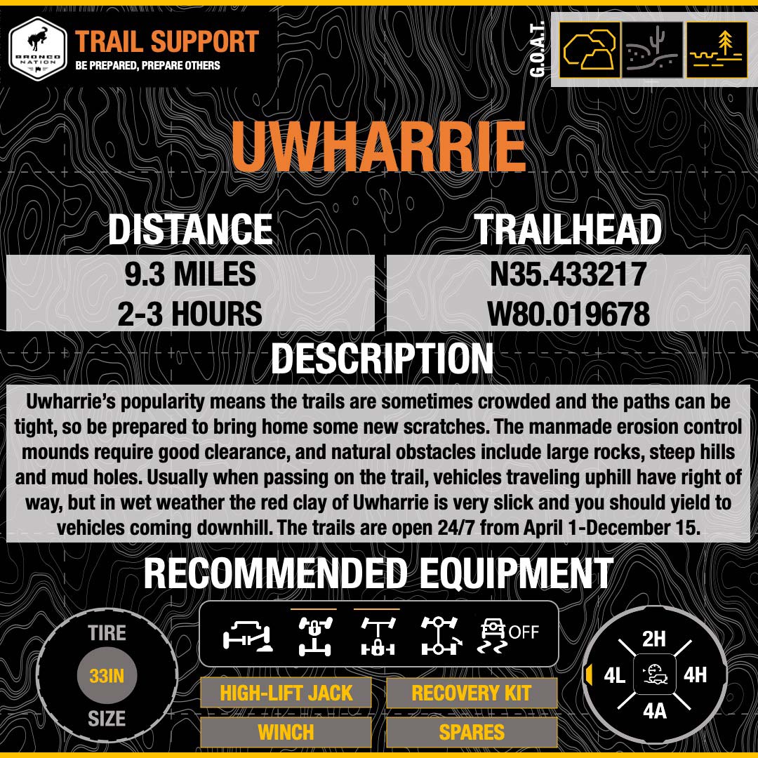
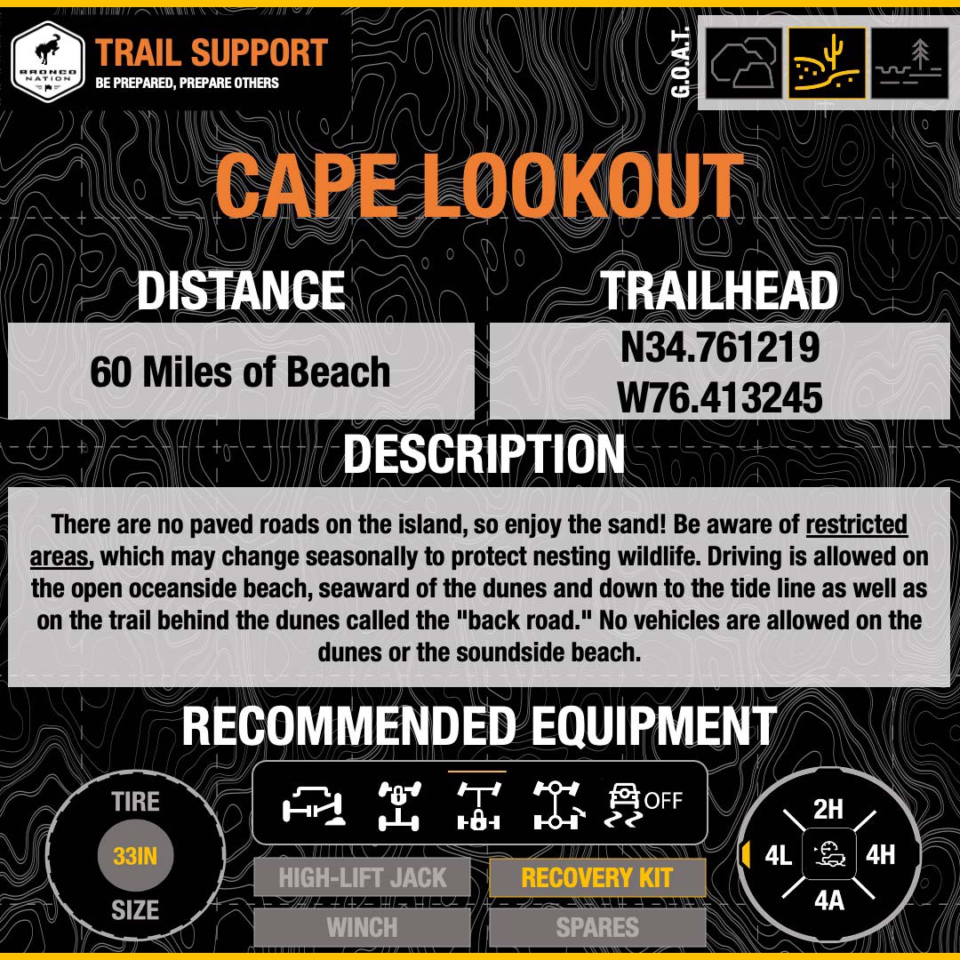
While the Southeast doesn’t have the same reputation for amazing trails as the Mountain West, it has an outstanding variety of terrain that can surprise and challenge you. You’ll encounter everything from sand to swamp, mud to mountain, palm trees to pine trees. The trails we’re highlighting offer features like creek crossings and mudholes, as well as unexpected obstacles in the form of fallen trees and, well, excessively big mudholes. Some of the state wildlife management areas and forest roads you’ll be entering are more often sought out for hunting, hiking, dirt biking, boating, camping, or fishing, so off-roaders who respect their surroundings will help keep these trails open to our preferred recreation as well.

In order to protect your surroundings and yourselves, you’ll need to plan and prepare. When you’re heading into the wild, you’re heading out of reliable cell phone coverage, so bring paper maps or a dedicated GPS unit. Pack a first aid kit, plenty of water, and weather-appropriate clothing. Bring a tire gauge and an air compressor so you can air down and back up. And have a recovery kit so that if you get stuck, you can get unstuck. If you’re not experienced using this gear, bring along friends who are, until you learn those skills. Not sure where to find those knowledgeable friends? Join the community conversation in the Bronco Nation forums!

Location: About 25 miles north of Palm Beach, Florida and conveniently accessible from I-95

Terrain: Trail #6 is a great one for beginners or wheelers who don’t want to scratch up their vehicle. It’s flat and open with an enjoyable combination of sugar-sand and mud. While driving into the Wildlife Management area on the paved access roads Stumpers Grade, South Grade, and North Grade, you may also encounter a few water crossings that can get deep after rainfall.

Considerations: Unless you have a hunting permit, you’ll pay a $6/vehicle entrance fee and be required to stay on pavement, except on Trail #6. Don’t forget your buddy and your recovery equipment, in case you get stuck in the mud.

Video: https://www.youtube.com/watch?v=MOrB1IpJCLg (trail footage)

Location: Near Toccoa, Georgia

Terrain: This route is a well-maintained gravel road taking you 3 miles up Curahee Mountain, a 1000 ft. elevation change. The trail ends at a telecommunications tower near the summit where you can park, enjoy the view, and continue on foot to the top if desired.

Considerations: The last mile of the trail is steep, so caution is called for, but no special equipment is necessary. When you travel the Curahee Mountain Trail, you will be following in the footsteps of American paratroopers who ran up and down this mountain for physical training while preparing to fight in Europe in World War Two. You can also visit the site of the paratrooper training camp and the military museum in Toccoa, if you want to learn more of their story.

Video: https://www.youtube.com/watch?v=A4xRXRabC2U (trail footage)

https://youtu.be/KHos-t9w5_A (Camp Toccoa history)

Location: Not to be confused with Conasauga Falls Trail in Tellico Plains, Tennesee, this 27 mile route begins in Crandall, Georgia off US Highway 311 and takes you to Lake Conasauga between the Grassy Mountain and Bald Mountain peaks in the Cohutta Wilderness.

Terrain: The north Georgia mountains peaks rising to 4000 feet in elevation are thickly covered in pinewoods. Forest Roads 630 and 17 are gravel and dirt, with various trails branching off and multiple creek crossings.

Considerations: This trail doesn’t require 4WD, but it surely going to feel better rolling over the gravel and mud in a Bronco than anything else. You need to be prepared for fallen trees, which may require winching or a chainsaw.

Video: https://www.youtube.com/watch?v=88DZZIQ4p-c (Overlanding in the region)

Location: In central North Carolina, easily reached from the major urban centers of Charlotte, Raleigh-Durham and the Piedmont Triad

Terrain: Sometimes when you go wheeling, there’s one trail, take it or leave it (see J.W. Corbett WMA, above). But not at Uwharrie! Uwharrie boasts eight OHV trails, between 1.1 and 3.5 miles in length, ranging in difficulty from moderate to very tough. There is a corresponding abundance of good reviews on alltrails.com, both from first timers and more seasoned wheelers.

Considerations: Uwharrie’s popularity means the trails are sometimes crowded and the paths can be tight, so be prepared to bring home some new scratches. The manmade erosion control mounds require good clearance, and natural obstacles include large rocks, steep hills and mud holes. Usually when passing on the trail, vehicles traveling uphill have right of way, but in wet weather the red clay of Uwharrie is very slick, and you should yield to vehicles coming downhill. The trails are open 24/7 from April 1-December 15.

Video: https://www.youtube.com/watch?v=KVfHymrGHDc (drivingline.com feature) https://www.youtube.com/watch?v=1fsKRXLlluU (trail footage)

Location: Stretched along two of North Carolina’s beautiful, remote barrier islands, North Core Banks and South Core Banks

Terrain: There are no paved roads on the island, so enjoy the sand! Be aware of restricted areas, which may change seasonally to protect nesting wildlife. Driving is allowed on the open oceanside beach, seaward of the dunes and down to the tide line as well as on the trail behind the dunes called the "back road." No vehicles are allowed on the dunes or the soundside beach.

Considerations: Unlike any of the other trails we’ve highlighted here, you can’t visit Cape Lookout on a spontaneous daytrip. But if you enjoy overlanding expeditions or primitive beach camping, this is an unforgettable destination. You will need to purchase an ORV driving permit online before your trip. The vehicle ferries are privately operated and charge $75+, depending on the length of the vehicle.

Video: https://www.youtube.com/watch?v=vyDmtJE-DGs (trail footage)

Video: https://www.youtube.com/watch?v=mvdwl6MHMiA (considerations)

Which trails in this region do you enjoy?

Comments

You must log in or register to post here.