
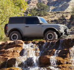
Toquerville Falls Bronco Ride
La Verkin, UT, USA
By quadsinthemudd (Rank 0, 31518)
START DATE Wednesday Feb 28, 2024 at 10:00 AM GMT-07:00
END DATE Wednesday Feb 28, 2024 at 6:00 PM GMT-07:00
Event Type
trip
Region
All Regions
Vehicle Type
Bronco
Length
19 miles
Difficulty
moderate
About the event
Event details
Time Ride Starts: 10am
Breakfast Time: 8:30- 9:30ish
Trail length: 19 miles in about 6 hours
Suggested equipment:
35+inch tires
At least a rear locker or strong tow points
A radio capable of Channel 19 (462.6500MHz)
Camera
Lunch
I was able to make it to Toquerville Falls in October 2023 but did not have enough time to do the full loop that includes Rattlesnake Gulch. I am coming back to attend United by Broncos and thought this would be a great time to hit the trail and have others with me just in case. I have seen many videos and write ups about this trail and it looks a bit challenging but a blast! I don’t feel it is a good fit for Bronco Sports or some small tired Broncos. To see what awesomeness awaits check out the many videos on youtube of the Rattlesnake Gulch trail.
Here is the write up from OnX
****************
Trail Overview
A very challenging 6.4-mile trail that goes through the canyon, along Laverkin Creek, to the Toquerville Falls Trail, which takes you on to the Falls above Toquerville/Hurricane, UT. You cross the creek a minimum of 40 times, and there are places where you drive up through the creek. After a heavy rain, or in the springtime, these water crossings will be deep and fast. (Trail Rating of 7 would fit then.) There are big rocks, areas of erosion, and mud at some of the crossings. There is one roughly 6-foot vertical wall that you go down on your way up to the Falls, and you have to climb it on your way out. Our group had two YXZs, one Razor, and one CanAm. We had tires ranging from 30 to 35" and we all made it back up the wall. The 35" tires had the easiest time in the canyon. The others put their skid plates to the test in places. We labeled it a "dirt" adventure, but along the creek, it's mostly a "rock" and "water" adventure. The Falls is a favorite tourist spot, and it is accessible from a road, so it can get a bit crowded at the top, but only the truly adventurous will go through this canyon. The trail at the bottom is mostly dirt; at the top, it's mostly rocks. There is a little off-camber, but nothing too drastic. In most places, there is room to get over and let an oncoming vehicle pass. Photo opportunities abound all along the creek. If you bring your suit, you can swim in the creek right below the Falls or further down the canyon. Bring a picnic lunch to enjoy at the Falls.
Difficulty
Late in the fall, this trail is a 6. After a heavy rain or in the early spring, it could be a 7. There are lots of boulders, some slick rocks, areas of off-camber driving and a LOT of water crossings. There is one 6-foot vertical wall that you go down on your way up to the Falls, and you climb on your way back down the canyon. We had two YXZs, one Razor and one CanAm in our group, and our tires ranged from 30" to 35". We all made it up the vertical wall. The 35" tires were a big plus in this canyon; anything less tested their skid plates on a lot of rocks. Some of the water crossings are muddy, there are areas where you have to drive up the creek for a ways, and there are areas of erosion and off-camber driving. It's not really fair to say this is a dirt adventure, but primarily dirt/rock/water.
****************
Optional Breakfast Location: River Rock Roasting Company 394 S State St, La Verkin, UT 84745
N37 11.6735 W113 16.5626
Fuel and End Location: Maverick Fuel Station 460 N State St, La Verkin, UT 84745
N37 12.6408 W113 16.2832
Trailhead and air down Location: La Verkin Shooting Range
N37 13.6483 W113 15.1492
Toquerville Falls
N37 17.9285 W113 14.8092
Air up Location:
N37 15.9829 W113 16.7261
We are gathering at River Rock Roasting Company at 8:30ish for a quick bite and for some who need it, coffee. Then @9:30 headed over to the local Maverick fuel station to top off those who need it and one last chance to use the facilities before the only thing we will have to use is tree-cilities! If you do not need to fuel or go to the restroom you can go directly to the trailhead and start airing down for a more comfortable ride.
We will be having a quick drivers meeting at the trailhead @10am then immediately departing. Please bring your lunch, it is a long day and we will be stopping to eat along the trail.
After lunch we will arrive at Toquerville Falls, we will be lining up in the river for a group photo. After the group photo we can move Broncos out of the way so you can get individual photos or little group shots of your close friends.
After the falls there is an optional short trail to an overlook. That will be if time is permitting or if the group doesn't care how late it is because Broncos have lights.
At the air up Location if you do not have your own air compressor we can all share and get you up to safe highway pressure if you would like. If you are going wheeling the next day at United by Bronco you just need to decide what you would like to do.
I have save all the waypoints and trail file in a KML
There is also an event page on Facebook here is the link:
https://fb.me/e/3PnTYgnto
Tickets
Price: Not defined
Media


Attendees
quadsinthemudd (Rank 0)
Member number: 31518
Published events: 5
Member since Aug 11, 2023
Attending (0)
No users found
Not Attending (0)
No users found
Comments
You must log in or register to post here.