By Dusty Sharp:
Southern California Bronco owners have many destinations to choose from when it comes to enjoying their vehicle and the great outdoors. The San Bernardino Mountains provide not only great off-highway adventures and sweeping vistas, but also rich and interesting history to explore. One such destination is the original route into the Big Bear area—a road which we can still travel today as Clark’s Grade Road, or US Forest Road 1N54.
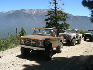
Clark’s Grade is an easy drive for Broncos of just about any level of modification and drivers of every skill level.
The verdant mountain valley that now cradles Big Bear Lake and its surrounding resorts had been inhabited by Native Americans for thousands of years by the time the first non-native explorer discovered it in 1845. Benjamin Wilson had been appointed Alcalde by the Mexican governor of California, Don Pio Pico, and charged with pursuing a band of renegades who had been raiding the local ranchos. From his ranch in the present-day Riverside area, Wilson and his band of 22 men rode up into the San Bernardino Mountains by way of the Santa Ana River. They then passed over a high ridge to the north, into what Wilson would name “Bear Valley” due to the abundance of grizzly bears.
The trail remained largely unused in the years after Wilson first traversed it until prospectors began exploring the mountains in search of riches. One such prospector was William Holcomb, who climbed Clark’s Grade in 1859 to try his luck in the as-yet unproven diggings in Bear Valley, at a camp the unsuccessful miners had dubbed “Starvation Flats.” To alleviate the situation that resulted in the camp’s unfortunate name, Holcomb hunted the area’s grizzlies for meat. And it was the pursuit of one such bear—a particularly large bruin he had wounded and tracked over a ridge into the next valley to the north—that led to his discovery of the rich gold deposits in the area that would soon bear his name: Holcomb’s Valley.
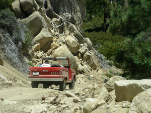
In places, Clark’s Grade is a narrow shelf road cut right from the granite
Southern California’s largest gold rush ensued, bringing more and more traffic over the treacherous routes that led up into the mountains. Wilson’s route up the Santa Ana and over the ridge into Bear Valley was the shortest route from Los Angeles and the growing towns of the San Bernardino Valley. But the route was steep, narrow, and rocky, barely suitable for horses and mules. So the earliest wagon roads into the area were cut from the high desert to the north. These required a multi-day trip, first up Cajon Pass, then around to the north side of the mountains, and finally over the new routes into Bear Valley. Due to its shorter distance, however, the Santa Ana River route continued to be used by those on foot and horseback.
In 1884, a dam constructed at its western end impounded the waters of Bear Valley, forming what is now Big Bear Lake. The dam, and the lake, would be enlarged several times over the years, and its value as a recreational destination would grow. As the gold began to play out, recreational uses of the Bear Valley area increased, with several resorts springing up in the area. Seeing the need for an improved road, suitable for wagons but shorter than the circuitous northern route, lodge owner Gus Knight began construction on improvements to the old mule trace that climbed over Clark’s Summit from the Santa Ana River. Completed in 1899, Clark’s Grade now made it possible to reach the mountain resorts in only a single day’s travel by stagecoach.
The many switchbacks on Clark’s Grade provide sweeping vistas to either side of the vehicle.
There was a stage stop at the bottom of the switchbacks at Clark’s Ranch for changing fresh horse teams and refreshing passengers before the steepest part of the ascent. Clark’s Ranch can still be visited today, in a short detour from the present route of Clark’s Grade Road. The ranch lies along the original route that followed the Santa Ana River (now Forest Road 1N64 or Seven Pines Road) up into the mountains. All that remains today are some old foundations and a watering trough, but a wide meadow and large shady oak trees still make it a great place to stop for lunch along the trail. The ranch no longer sits right along the Clark’s Grade route, because after severe flooding wiped out the Santa Ana River road along its many water crossings, a better route to the foot of Clark’s Grade was completed in 1914, called “Middle Control Road” (another obsolete route, part of which may still be traversed today from Angelus Oaks to the base of Clark’s Grade).
Over the years, Clark’s Grade has been a preferred route of Native Americans moving from the mountains to the valleys, mountain men and prospectors, ranchers and rustlers, and freighters and stages—both horse-drawn and motorized. Some of the route’s more colorful history is from early motorsports, where the grade proved a tough challenge. In 1910 Jack Heyser attempted to race up the grade from Redlands in his White Steamer. According to accounts, “At the Santa Ana, we fired her up to 1,000 pounds of steam, hit the crossing at thirty miles per hour. The entire hood went out of sight, the fires were put out and we were all drenched. Above on the winding, narrow, rock trail, clinging to the mountainside by its eye-whiskers, we ran out of water for the steamer. Opie found a spring and brought five gallons. The steam gauge rose to 600 pounds, and we topped the summit of Clark’s Grade.”
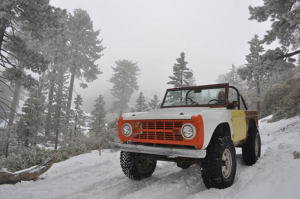
Be careful in winter, as snow can be heavy near Clark’s Summit and the gate may be closed in winter.
Of particular interest to Ford fans, in 1917 there was a contest to see who could reach Bear Valley first after heavy winter storms. Twenty cars entered, including a Ford, Two Briscoes, a Cutting, a Le Zebre, and various others. The Ford blew out a cylinder early on and had to be re-fitted with a new one. Heavy snows on Clark’s Grade further hampered contestants, at one point necessitating a hike back down the hill to fetch wooden-clad “snow tires.” But their efforts were in vain, as after nine days of fighting the deep snow, the teams finally deemed the summit unreachable. The only two cars left in the race, including the Ford, had to be left in the snow for almost two weeks. The teams finally returned to dig the cars out, and the Ford crossed the finish line first, three weeks after leaving San Bernardino.
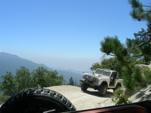
An improved route from Redlands to the Big Bear area (later re-designated CA State Highway 38) would render Clark’s Grade and its hairpin switchbacks obsolete by the 1930’s. But the road survives today as a scenic, easy-to-medium challenge for off-highway driving enthusiasts. Along the way there are mountains, streams and sweeping views of the vast Santa Ana River gorge to enjoy. In places, the route is hewn from nearly vertical rock faces, with a precipitous drop-off on one side and a vertical cliff wall on the other side of the narrow shelf road.
Clark’s Grade Road is suitable for stock 4x4s and SUVs with sturdy tires and good ground clearance. Stock and slightly modified Broncos should have no trouble, but due to the remoteness it is recommended to travel in groups of at least two vehicles. Note that snow and storm runoff may change trail conditions, and the gate at the summit may be locked in winter, so contact a USFS Ranger Station for updates before heading to the trail.
SOURCES
LaFuze, Pauline B., Saga of the San Bernardinos. Bear Valley Historical Society, 1971.
Nash, Brian, XNGH, Clark’s Grade Road. E Clampus Vitus and the Society of Vituscan Missionaries, 2012.
ONLINE RESOURCES
Clark’s Grade Road on Google Maps: https://goo.gl/maps/QEv3fwEKq1LEYhPM9
US Forest Service road map of the San Bernardino National Forest: https://usfs-public.box.com/v/bdf-mvum-north
WAYPOINTS
Getting There 1: Leave Highway 38 at Middle Control Road: 34°09'01.8"N 116°58'32.4"W
Getting There 2: Crossing Santa Ana River: 34°10'18.3"N 116°56'58.6"W
Getting There 3: Left on Forest Road 1N09: 34°10'22.0"N 116°57'01.5"W
Clark’s Grade Road 1: Keep right at Forest Road 1N54: 34°10'20.3"N 116°57'09.8"W
Clark’s Ranch Side Trip 1: Turn Left at Forest Road 1N64: 34°10'60.0"N 116°58'15.5"W
Clark’s Ranch Side Trip 2: Clark’s Ranch: 34°11'01.8"N 116°58'39.0"W
Clark’s Grade Road 2: Potential Difficult Spot: 34°11'11.8"N 116°58'05.3"W
Clark’s Grade Road 3: Switchback View Spot: 34°11'28.6"N 116°57'31.2"W
Clark’s Grade Road 4: Narrow Shelf Road: 34°11'49.2"N 116°57'24.4"W
Clark’s Grade Road 5: Clark’s Summit (Gate May Be Locked In Winter): 34°12'31.1"N 116°56'42.2"W
Clark’s Grade Road 6: End at FS Road 2N10 (turn left and stay on 2N10 to get to Big Bear Lake): 34°12'34.3"N 116°56'40.6"W
SHORT AUTHOR BIO:Dusty Sharp is a Bronco enthusiast who bleeds Ford blue. He is also a freelance marketer, published fiction author, and amateur historian. He founded So Cal Broncos, the Early Bronco Brotherhood of Southern California, in 2001, and is a proud member of E Clampus Vitus, an irreverent historical society. His books can be found at http://www.dustysharp.com.

Comments
You must log in or register to post here.